Central Mongolia
Central Mongolia
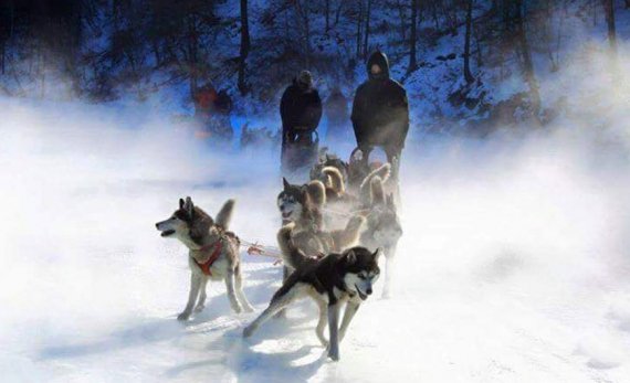
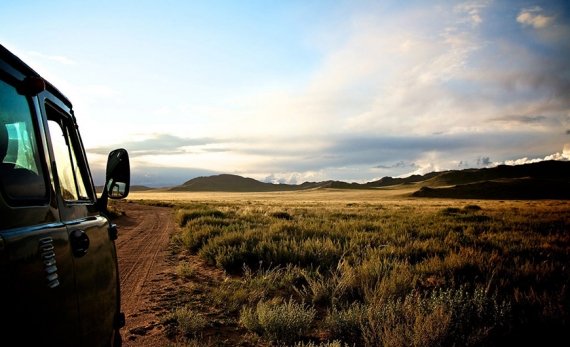
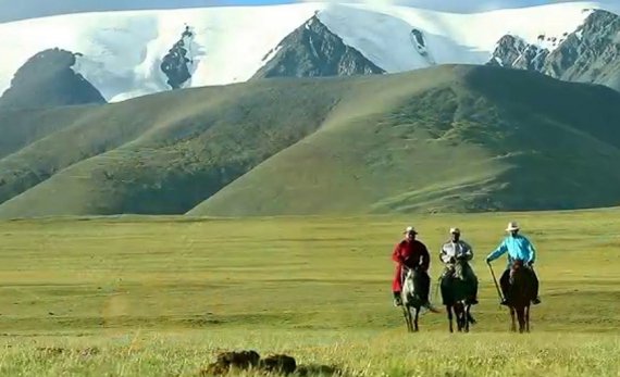
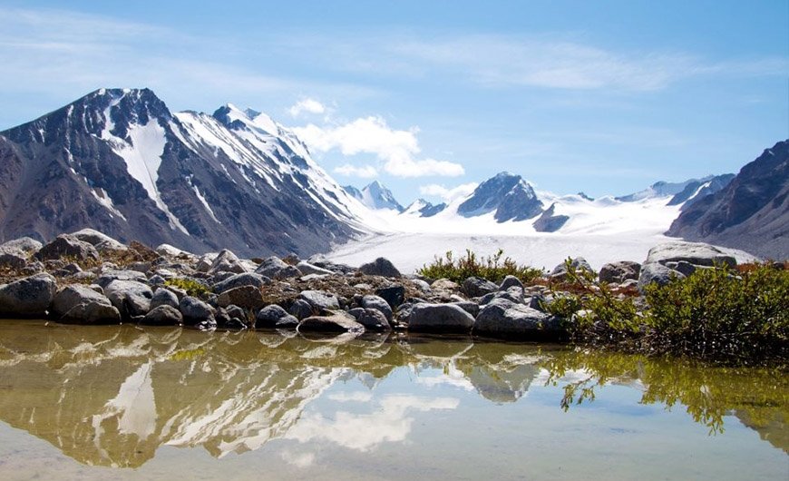
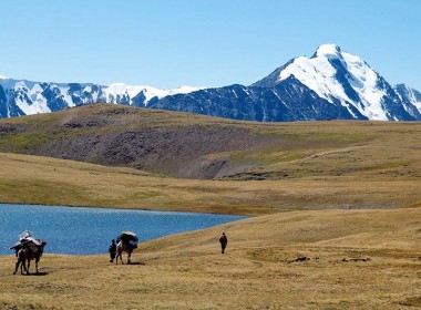
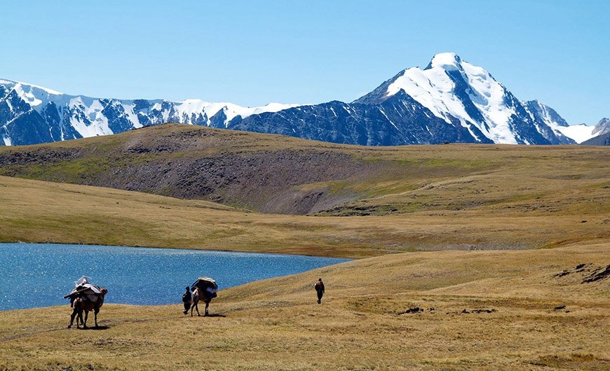
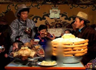
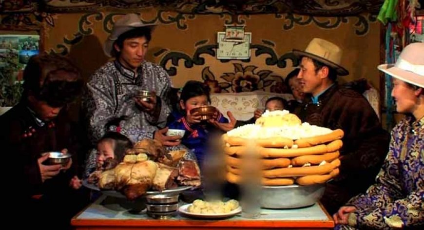
Central Mongolia is beautiful landscape and where are many important historical and cultural remains of different historical periods. In central Mongolia, you can discover distinctive natural zones of forested steppes, mountain steppes and Gobi desert and their breathtaking natural beauties and interesting cultural and historical items. Verdant swaths of empty landscapes are sprinkled with tiny gers (traditional yurts) stretching to the horizon while magical light plays across the valleys. This is the Mongolian heartland, loaded with both historical sites and natural beauty, with plenty of scope to horse trek in forested mountains, camp by pretty lakes or soak in hot springs.
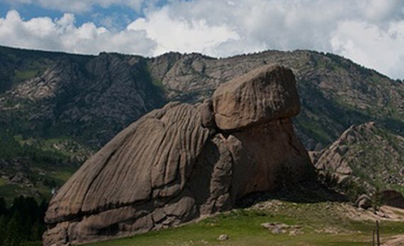
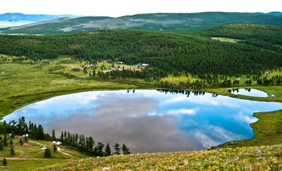
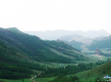
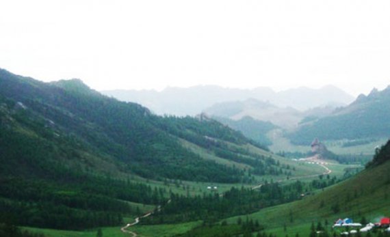
TERELJ NATIONAL PARK
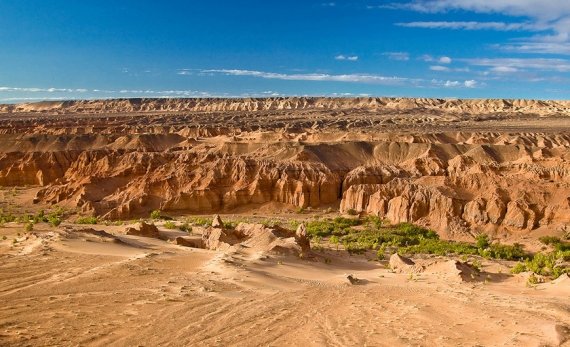
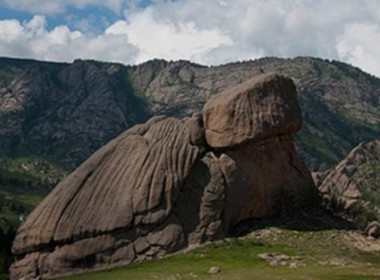
Terelj national park is designated as a National park in 1970-s and is the place, where Mongolians want to travel and relax with excitement on wild nature. Terelj National park landscape is very picturesque on forests, granite rocky hills, rocks with interesting shapes, rivers and green meadows. There every person is impressed with the nature beauty and color harmony. Strolling on green meadows carpeted with edelweiss and a dazzling variety of wild flowers, exploring the fascinating view of rock formations against a backdrop of pine covered mountains, riding a horse and galloping across bushes and streams are wonderful outdoor activity in this place.
Rock formations
Here some of the rocks resemble the long spiky bodies of prehistoric animals. The park comprises a small separated valley, where is the most spectacular giant turtle rock natural formation and a young man. Moreover, the park attracts geologists' attention considerably.
In beginning of 1990-s German, Chinese and Russian geologists made the research and prospect for jeweler stones. Stones in some places glitter in sunshine with incredible golden color.
Historical site
In 1696 Mongolian horse mounted army, consisted of more than 10.000 soldiers from main tribes and lead by famous army leader Chingunjav, made battle against Manchurian army in Terelj valley in order to make the country free off Chinese-Manchu. However, in this battle Mongolian army was lost in some reasons. Still today the some kinds of arrowheads are found in this rocky hills.
Princess Temple
The sanctuary for Chinese princess, who was presented to Mongolian influential lord in the reason of making the foreign relation and political atmosphere peaceful and constable, is dated to 1740. Next to the tomb is a stele once set on the back of a stone tortoise with an inscription by Manchu emperor Qianlong.
A sanctuary, surrounded by a wall of white stones, was built near the tomb according to the Manchu customs. Later this temple and walls were destroyed down in 1941.
Offertory site for Turkish King
Offertory site for Turkish King Tonyukuk, which is dated to 720 A.D, is a better example of blue Turkic remains. A few statues includes block of stone dedicated to Tonyukuk and inscribed with a long text in the runic characters of Turkish. The 62-line text of the Turkish inscription on the stele traces the life of Tonuykuk King and the historical events he took part in.
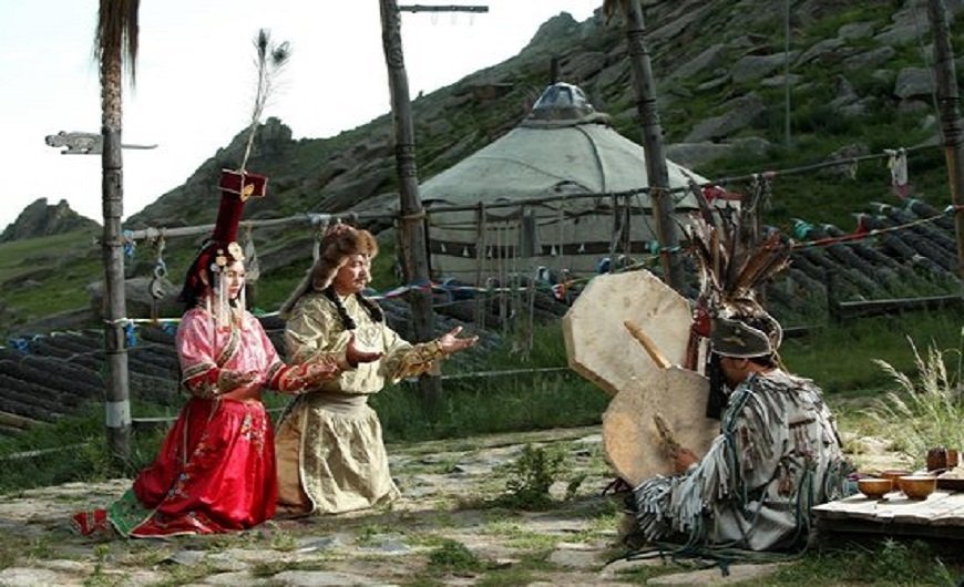
Aryabal Meditation Temple
According to the Kalachakra sect of Buddhism the mediatation is held usually in mountainous area in Mongolia. The meditation doing mountain should be granite rock and area should cover the area with frosen layers in deep ground all year around. In Mongolia buddhist monks used 3 places for doing meditation. One is Tovkhon Monastery in Khangain Nuruu National park, the second is this temple -Araybal temple in Terelj park and the third one is Baldanbereeven temple in Khentii province.
Aryabala meditation temple was built in 1810-s by mongolian and tibetan artists in Gorkhit valley of present Terelj national park. In many cases buddhist monks from Manzushir monastery came to this temple to make meditation. The temple style is more tibetan styled like white square shaoed and white colored main building and porcelain roofs decorated with buddhist and religious signs. In 1937-1939 mongolian communists came to this temple and destroyed it completely and killed some monks from this temple. Later in 2000 buddhist monks of Lamiran temple in Ulaanbaatar initiated the project to restore this temple and completed the restoration work in 2004-2007. Lamiran temple monks sometimes come to this temple and cater religious service here and in many days of year it is open place for visitors and tourists, who want to thank for the god and do meditation.
The decoration at the temple houses are amasing, especially depicting what is the paradise and what is the hell. Inside the temple houses you will see the stories of some enlightened men's stories at the house wallpaper and the main altare is Buddha Arya Bala.
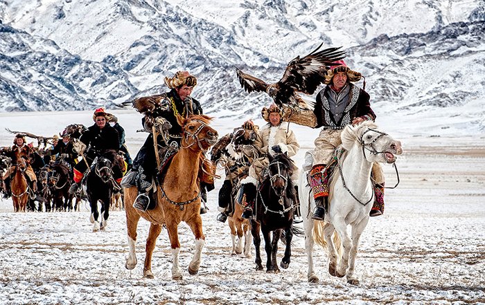
CHINGGIS KHAN STATUE ON TSONJIN BOLDOG HILL
Chinggis Khan is the man of Mongol nation pride. When Mongolia is became the democratic country, the human right come to every mongol man with Chinggis khan pride and traveling passport. In present time Mongolians are building a complex of Chinggis Khan Statue on Tsonjin Boldog hill, which is located in east of 90 km from Ulaanbaatar city.
40 meters high steel statue of Chinggis Khan is one of the Mongoian architetoral building, which is designed by mongolian architector B.Erdembileg and it houses for gorgeous restaurant, small art gallery, one hall for displaying archeaological findings dated to 3rd B.C. and one hall for history of Mongolian Empire in 13 century, conference room, big lobbies and observation deck for surrounding view.
The Statue is described that Chinggis Khan is holding a golden whip in his hand as mounting on his horeback. This is the historical place, where Temujin found a golden whip on this hill during his travel to Hereid tribe and it was a good omen to predict him to be the great king in the future.
In the restuarant you can have dining of European and Mongolian Cuisine. Also the statue complex has gate, which is decorated with statues of 9 generals of Chinggis Khan.
In art gallery you can enjoy Mongolian artists selected art works with Mongolian historical and cultural information. In the main lobby you will see the massive whip with 4 meters long and decorated with garuda birds. Next to it there is a very big mongolian boot, which size is 4678 and appr 250 cow skins and 10000 meter needle was used to make this boot.
13TH CENTURY CULTURAL PARK
13 Century Cultural Park comprises Chinggis Khan's statue and museum halls and Live museum "Town from 13 century". The ancient town live museum is located in the distance of 130 km east of Ulaanbaatar in area of Erdene sum of Tov Province. It takes 2 hours driving on paved road.
A 40 meter statue of Chinggis Khaan mounted on horseback and holding horsewhip will be discovered on the way to Alive museum of 13 th century. The musem displays the authentic lifestyle of mongols, who were living in Chinggis Khan's period and offer travellers real experience and real feeling on travel this ancient world. This place gives them a feeling of that travellers came to ancient time in time mashine.
The complex is consisted of 350 hectare field and it consists of 12 main complex areas and have lots of animal collection such as mongolian dog, wolves and eagle. Travellers will walk in this city or they can rent horse or camel passing through this city at no charge.
Warriors, who are dressed in ancient national costumes-armours and holding spears and swords, will greet travellers near the main gate of this mini world. Travellers should get the Gerege /used as passport in 13 th century/ and they have right to enter the city.
Defence Complex
Warriors, who are dressed in ancient national costumes-armours and holding spears and swords, greet travellers near the main gate of this mini world. Travellers should buy the gerege /used as passport in 13 th century/ and they have right to enter the city.
Ger complex of Craftsmen
Explore mongolian ladies, who are sewing national clothes, craftsmen, who are doing some decorative things and applied art works, men, who are making swords and spears near the fire, and other people, who are doing householding items for themselves.
Ger complex of Royal People:
Royal family people live here and their ger is open to travellers. Explore how the roatl people dressed and how they lead the state work, meeting, and how they enjoy in palace performance.
Ger complex of education and books
Educated people are living and doing their paper works, history books anf inventing mongolian Yigur alphabet in this gers. Travellers can have their names written in old mongolian script.
Nomad Gers complex
Explore there how nomads: horsebreeders, shepherds and cattle breeders are living in small different gers and what they are eating and drinking.
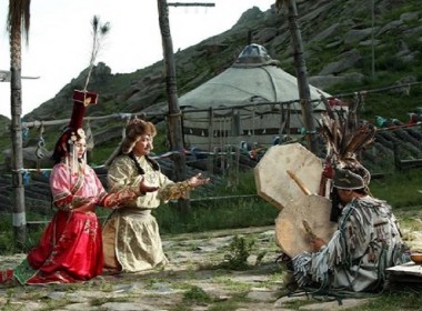
Sacred Diety - Shamanism Ger complex
Most of mongols believed in shamanism in 13-th century, so this gers show how shamans are living and what they are doing for public and for the state.
Great Court ger complex
This complex show how the laywers are regulating the society with special law Great Yasa. Of course, in this area there are no any jails. See how people are punished for their crimes: polluting nature, stealing something, breaking their promice to their friends…
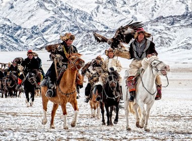
Hunters Tent Complex
Here explore how the hunters are hunting with their eagle or in special tecnics of archery shooting. Explore the blue skins and furs of hunted animals processed by hunters.
Ger complex of migrating people and refugees
Explore how the pilgrimagers and refugees are living and in this place.
Main commercial street
Walking in the commercial street and change your USDollars into 13-th century coins and “shopping” in ancient market.
Special Ger complex for travellers
Travellers can have rest and relax and enjoy some special service for travellers.
BOGD KHAN MOUNTAIN NATIONAL PARK & MANZUSHIR MONASTERY RUINS
Bogd Khan Sacred Mountain Park
Bogd Khan national park is located in south of Ulaanbaatar city. The Bogd Khan Mountain, along with Mongolia's other sacred mountains Burkhan Khaldun and Otgontenger, was added to the UNESCO World Heritage Tentative List on August 6, 1996 in the Cultural category. World Heritage sites are those that exhibit universal natural or cultural significance, or both.
In 1778 the Mongolian governor (minister) of Khuree (Urga, present day Ulaanbaatar) Sanzaidorj sent a letter to the Qianlong Emperor, Manju's Ching Dynasty, requesting approval of annual ceremonies dedicated to Mount Bogd Khan Uul. The Mongolian letter and the reply from Beijing in Mongolian is kept in the Central State Archives of Mongolia.
The Mongolian letter said: "This mountain is called Khan Uul because Genghis Khan had lived here originally. Indeed the many princes, dukes, banner governors, saints and disciples of the Khalkha all regard this mountain as marvelous and the former old Khutugtu (Zanabazar) himself worshipped it. Until now the many locals here never hunt the animals of the mountain as if they were entitled to hunt them, nor do they move the trees as if they had the right to do so. ........... Pronounced earnestly for this reason, we beg Royal Decree." The reply letter meaning is "have accepted your request. Please, Make this mountain protected sacred area and keep the ceremony for this mountains". That is why this mountain is officially declared first protected area, , on the world.
Manzushir Monastery Ruins
Manzushir monastery was housed by 400 monks and religious ceremony held by over than 1000 lamas. The monastery was renowned throughout Mongolia for its religious service and its celebrations of Tsam /religious dance/. In 1700-1800 the monastery consists of 14-17 halls, artificial lake in front of what was the main temple.
In 1937 communist purges all of the halls were destroyed down completely. Later in 1990, after the communism collapse, several years' restoration work has brought some of the buildings back to life.
Rock carvings and paintings
Rocks engraved with Buddhist images are located in lovely hills near the temple ruins. One represents the Zonkhov /1357-1419/, founder of the Gelugpa school of Tibetan Buddhism , and second shows the Bodisatha, considered the patron of the Manchu. A third rock is engraved with a design of an elephant, hare, monkey and bird, which known as the allegory of cooperation.
Local museum “Nature” and other sights
A small museum of flora and fauna was built in 1972 neighboring to the temple ruins. The museum exhibits the model of the original temple, as well as small skillfully done images from natural elements: wood, sand, feathers, stones and fur.Open air archaeological remains at the side include the large cauldron, 2 m wide and 1 m tall, with inscriptions in old Mongolian script. One of the incriptions dates to the cauldron to the summer of 1730. Another explains that it was used to boil water for tea. Also there is a large bell /1m height/ dates to reign of the Manchu emperor. There are tent design and Mongolian Ger museum, which is completely fitted with Mongolian national furniture.
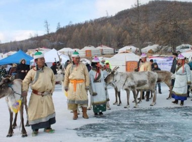
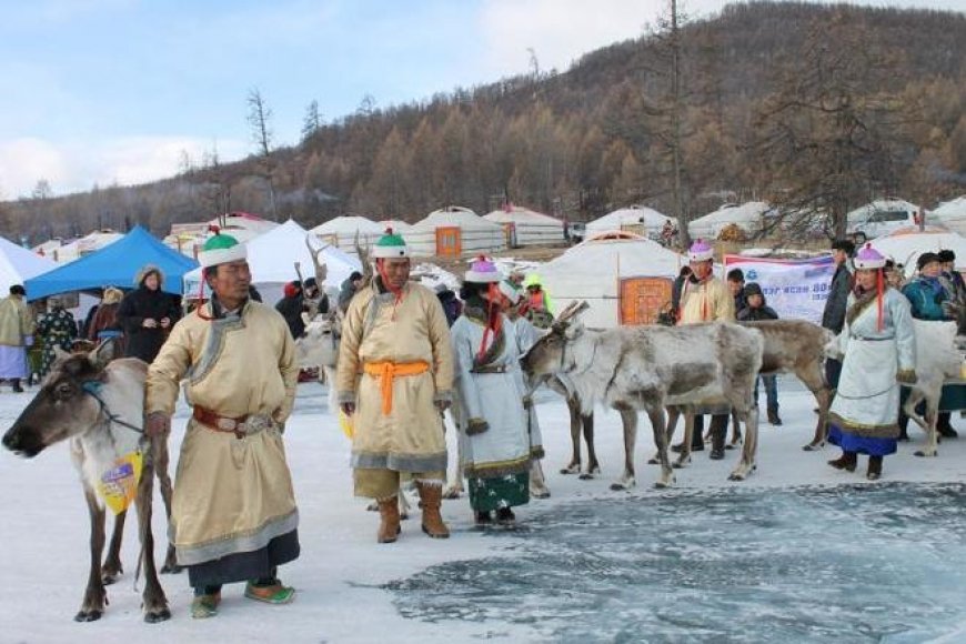
GUN-GALUUT (Argali National Park in Mongolia)
Amazingly, Gun-Galuut is the state combined from diversity of ecosystem although it owns comparatively small area. The harmonized complex of high mountains, steppes, rivers, lakes and wetlands as well are kept enough as its original condition. Whoever visiting enjoys to see Gun-Galuut vast steppe seems to meet the sky, the imposing mountains Baits and Berkh, a home land of rare creatures, Ikh-Gun and Ayaga lakes, a paradise of birds, Kherlen, the longest river of Mongolia and Tsengiin Burd wetland, in where water and wetland birds lay their eggs.
Gun-Galuut Nature Reserve is a local protected area for conservation of global threatened species. The Nature Reserve (NR) is founded by the Citizens' Representative Hural (Local Parliament) of Bayandelger county, Tuv Province in 2003.
Gun-Galuut Nature Reserve comprises of 3 zones: tourism, limited, and core zones, which are the ecosystem of steppe, rocky mountain, small lakes, river, streams and wetland, and it is about 20000 hectare.
The advantages of Gun-Galuut is no overcrowd of people mixed with domestic tourists although it’s located just 130 km from Ulaanbaatar capital city and easy access of driving (just for 2 hours) make this area to become the most attractive place for the tourism.
The fauna and flora of the NR haven't been researched properly but currently 63 mammal species, 81 bird species, 3 amphibian species and 38 fish species are recorded. Most common species are Grey Wolf, Marmot, Souslik, Pika, Vole, Fox, Corsac, Jerboa and Frog.
There are many nationally and globally threatened species in the NR. For instance, Argali Wild Mountain Sheep, Siberian White Crane, White-naped Crane, Hooded Crane, Red Falcon, Black Vulture and Swan Goose are globally threatened and listed in the IUCN Red List. Also there are nationally threatened species such as Whooper Swan, Black Stork, Great White Egret, Bar-Headed Goose, Bearded Vulture and Eurasian Penduline.
GEOGRAPHY
Amazingly, Gun-Galuut's vast and diverse landscape has tarditionally been a refuge for a rich and unique assemblage of animals, and it's combined from diversity of ecosystem although it owns comparatively small area. The harmonized complex of high mountains, steppes, rivers, lakes and wetlands as well are kept enough as its original state. Whoever visiting enjoys to see Gun-Galuut vast steppe seems to meet the sky, the imposing mountains Baits and Berkh, a home land of rare creatures, Ikh-Gun and Ayaga lakes, a paradise of birds, Kherlen, the longest river of Mongolia and Tsengiin Burd wetland, in where water and wetland birds lay their eggs.
Mountain Ranges
The area of Gun-Galuut Nature Reserve is elevated averagely 1200 m above sea level, topped by Mt. Baits and Berkh at the altitude of 1641 and 1631 m respectively, and are rocky. The area has several terrestrial ecosystems such as mountains, hills and steppes. Mt. Baits range locates in the center of the area, and Mt. Berkh locates at the south end of NR like stretching from north-west to south-east. The both of them has many species of fauna and flora.
The most interesting thing is the Mt. Baits has only one tree Larch. As for fauna, argali sheep, grey wolf, fox, lynx, manul cat, badger, hare, marmot, mice and etc.., White gazelles or the Procapra gutturosa often come from the east to this area. As for birds, Steppe Eagle /Aguile nipalensis/, Golden Eagle /Aguila chrysaetos/, Saker falcon /Falco cherrug/, Kestrel /falco tinnunculus/, Lesser Kestrel /Falco naumanni/, Upland Buzzard /Buteo hemilasius/, Long legged buzzard /Buteo lagopus/, Mongolian lark, Calandra lark, Crested lark, Horned lark, Thrushes, Pipits, Magpies and Hoopoes, Owls and Tawny-Owls.
Steppes
Gun-galuut Nature Reserve is in the westernmost part of the Great Mongolian Steppes. In steppe of the NR has Wetland Delberkhii, surroundings of Lake Ikh Gun and Ayaga at the north of the NR, basins of River Galuut and Kherlen. The wetland Delberkhii is the main water resource for Lake Ikh Gun and Ayaga, and other grounwater in Gun-Galuut NR. Also, since its soil fertility, plants, land characteristics and quality are pretty good, water birds and other biodiversities like to come here.
Lakes
Gun-Galuut Nature Reserve has numerous lakes and pools. The largest one in size are Lake Ikh-Gun (88 Sq.he) and Lake Ayaga (13 Sq.he). Most interestingly, Lake Ikh-Gun consists of 2 parts, 1 of which is sq.he and the other is 17 sq.he, and there’s a track between these 2 small parts, on which a vehicle can drive. These 2 lakes are situated at the northern part of tourism zone of the Nature Reserve. Many species of waterbirds spend summer at these 2 lakes, namely, gulls, ducks, geese, swans, cranes, storks etc., Lake Ayaga was mentioned by one of the well-known scientists of Mongolia, Dr. Dashdorj in one of his scientific articles as “ Lake Ayaga needs an immediate protection as it is a home for many species of worldwide endangered species of fish...”, in 1980s. Lake Ayaga is richer than the lake Ikh Gun in birdlife. There’s no outlet and inlet of Lake Ikh Gun, but Lake Ayaga has an outlet and an inlet.
Rivers
Gun-Galuut Nature reserve has many clear rivers including the River Kherlen, one of the longest in Mongolia, River Ayaga, River Shinebulag and River Galuutai and so on. All are rich in fish. River Ayaga flows from Lake Ayaga and joins the River Kherlen. Currently 38 species of fish are observed in the River Kherlen which flows from the Khentii Mountain range and joins Lake Dalai in Inner Mongolia. Fish species, Taimen (Hucho Taimen), Lenok (Brachymystax lenok), Amur pike (Esox reicherti), Burbot (Lota lota), Amur dase (Leuciscus waleski) and Flathead asp (Pseudaspius parva) and many more. The Nature Reserve is open for all 4 seasons with its rich fishery "Catch and Release" only, amazing nature beauty and wilderness. You have opportunities to fish for Taimen – The River King as the world class fishermen call it.
Wetlands
Ayaga wetland is a beautiful and rich wetland, a home for many species of animals and birds. The wetland is a wonderful complex of everything that a bird may need to live and breed. Many endangered and rare waterbirds also occur in Gun-Galuut, namely, Black Stork /Ciconia nigra/ is facing problems of extinction worldwide. It spends summers at Ayaga oasis of the NR peacefully.
HERITAGES
Gun-Galuut NR doesn’t only have rare and threatened species, but also it’s a very important place for historical and cultural heritage. We think that it's our responsible to conserve the historical sites and cultural heritages for our future generations. Protecting them from natural causes and human factors is very important. There are plenty of historic memorials, magnificent Hunnu period (209 BC) deer stone, several ancient grave mounds, etc., It's very wonderful thing that the Mongolian Great Poet D. Natsagdorj was born here. So the memorial monument was built on the cradle of ger /dwelling he lived/ for him.
Historical Sites
There are ruins of buildings including big mud wall as though there was an ancient town named Undur Dov, barrows, deer stones, etc., The Undur Dov is located between Lake Ikh-Gun and Ayaga of Bayandelger soum, Tov province.
It was discovered in 1925 by Russian scholars B.Ya. Vladimortsov and B.B.Baradin during their archaeological research for remains of ancient towns and settlements in Baga Khentii or Kherlengiin Terelj and vicinity of Ikh and Baga lakes. Later, Kh. Perlee made some archaeological excavations and came up with the definition and excavation map of the ruins of town. At the time of the excavation "Undur Dov" have battered remains of the fortified walls around the town, traces of the elevated structure on the walls, which were presumably used for observation by sentries and the remains of the square-shaped building in the center of the fortress.The wall is 410x420 m square, 1.5-1.2 m high and 4-5 m thick. Its all four side has a gate respectively.
Some of researchers date Undur Dov fortress back to the Hunnu period and some to the XIII-XIV century.
Cultural Heritages
Changing Mongolian old society, abolishing bondage for cultural revolution, launching and developing Mongolian Modern literature for Mongolian future generations, Borjigon Dashdorj Natsagdorj was born in place named Melzii (Ayagiin Am) of Bayandelger soum, Tov province in Nov 17, 1906.
An accordance with The Union of Mongolian Writers, the memorial monument was erected on the birth place of D. Natsagdorj in Sep 28, 1981. Now, this place is located 6.8 mile /11 km/ of west side from the Station Kherlen and 7.45 mile /12 km/ from bridge of River Kherlen.
D.Natsagdorj (1906-1937), one of some well known people is founder of Mongolian Modern Literature. Mongolian writer, poet, playwright, Natsagdorj Dashdorj was born in Bayandelger soum (county), Tov Province of an impoverished noble family due to an absence of formalized education in Mongolia.
Working in the Military Department as a writer since 1911, his father Ts. Dashdorj died in 1927. Unfortunately, his mother Pagma died in 1913 when Natsagdorj was 7 years old.
His father got Natsagdorj when he was 8 years old to learn literacy (Mongolian old script) under the tutor Altangerel, who was one of the great literates in Mongolia.
From at the age of 11, he was writer for the Military Department in 1917-1921 and at the age of 16, he joined with the Central Committee of Party as a member, and became secretary for the Military Council. Afterward, having studied at the of Leningrad, Russia in 1925 and graduating it in 1926, when he was 20 years old.
He had been working in Cabinet Secretariat of the Government of Mongolia as a director since 1924. Unfortunately, during the Mongolian Festival Naadam of 1937 he died in position of leaning the yard of the Central Theater.
He created many poems, fictions, verses, etc., For instance: /poem/ "To be appeared blue", "The song for youth", "Note on the way to Berlin", "Indian woman", "Wonderful", "Science", "Wanting freedom", "Oktyabri", "My native place", "My mammy", "Four season", "Dream", "My little lamb",etc., /fiction/ "White moon and black tear", "Tear of Lama", "Old boy", "Admiring culture", "Beauty of the countryside", "Thing that never had seen", etc.
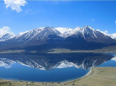
The full name of the lake is the Blue Lake of Black Heart. Black Heart is the pointed topped mountain on the north side of the lake. Blue Lake is a very important place in Mongolian history particularly of Chinggis Khaan (Genghis Khan). Here Temuujin (Chinggis Khaan’s childhood name) was given the title, “Chinggis Khaan”, and was invested as a “The Great Khaan of all Mongolia” in 1189. The stone ruins of a ger with a diameter of 15 meters on the south side of this lake could be the ruins of the palace ger where Chinggis Khaan was proclaimed khaan. There are also wooden statues in the forest dedicated to Chingis Khaan and the next 32 khaans of Mongolia. The surrounding area of Khukh Nuur is quiet, peaceful and wonderful for hiking & relaxation.
Ruins of Kharakhorum City
Kharkhorin locates in beautiful, wide valley of Orkhon river, 360 km southeast of Ulaanbaatar. This wide valley attracted attentions of kings of Mongol states of different periods such as capital of Huns State 209BC-98AD, Syanbi State, Nirun State, Turkic State 552-745AD, Uigur State 750-850AD, Kidan State were established there. Kharakhorum was a capital of the Great Mongol Empire between 1220 to1380. By the 15th years anniversary of Chinggis reigned as Khaan, who chose this area and issued decree to build capital city there. Building process of the capital city started in 1220 and continued by his successor Ogoodei Khaan. 413 silver coins of over 10 different countries found from where guaranteed that the city was more like trade center than capital city and was one of important stops of Silk Road. It surrounded by 4 by 4 km walls had 4 main gates. Different trade went on every gate. Residents of the city used to classify by their rank. There were over 10 temples, churches and mosques in Kharakhorum. It was totally sacked by warriors of Chinese Min dynasty in 1380
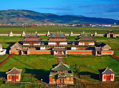
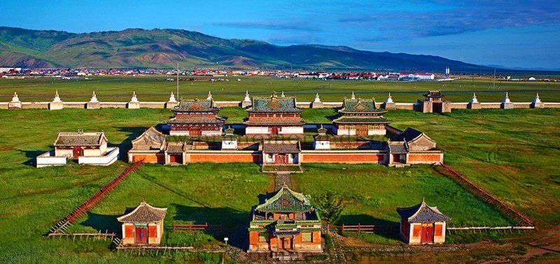
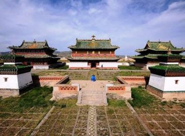
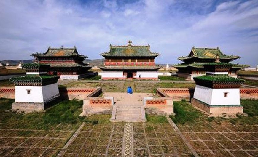
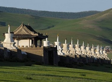
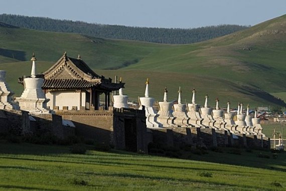
Erdenezuu Monastery
One of the destroyed monasteries of Karakorum city started to rebuild by idea of Abtaisain Khan who was 29th golden generation of Chinggis Khaan using old building materials of Kharakhorum city in 1586. Erdenezuu is the largest and oldest monastery in Mongolia. By 1793, there were 62 temples, over 500 gers and houses resided by 10000 monks inside its 400 by 400 m walls. In 1937, communists destroyed many of the monastery's temples. Now there are 28 temples serving as a museum displaying masterpieces of Tankas, appliques, embroideries and sculptures of the 17th -19th centuries. One of the temples is an active temple and the oldest Tibetan style temple in Mongolia. There are over 40 monks read religious mantra every day in warm seasons. The temples were built by Tibetan; Chinese and Mongolian combined architecture without using single nail is special.
Tovhon Monastery
Tovhon monastery built on the rocky top of Shiveet Ulaan Mountain 2312 m above sea level by Zanabazar as a creation temple and meditation center in 1654. Zanabazar was a leader of Mongolian Buddhism, first Bogd (living Buddha), famous painter, and sculptor and created Soyombo alphabet in the monastery. First letter of this alphabet is used as a national emblem on Mongolian flag. There, he also created green Tara and many famous creations. The monastery had 14 temples. Some of temples were destroyed by soldiers of Galdanboshigt, who was Khan of Oirat Mongol/eastern Mongolia and his view were against Zanabazar who decided to submit Manchu. Some of the temples were also destroyed by 1930s communist purge. Now, there are 4 temples and 2 stupas under state protection and its chanting activity has been recovered since 1992. The temples and stupas restored in 2001. The monastery registered in UNESCO as a World Cultural Heritage in 1996. The monastery is not only reason to head to there, also in the surroundings of the monastery, there are many interesting caves, huge sacred trees and you can have amazing vista from the top of the mountain. The valley of the Orkhon River is full of ancient historical items and nomads and their countless animals pasturing freely in the wild make tour more impressive. We recommend Tovhon Monastery people who like hiking, rock climbing and horse riding.
Hugnu Khan Mountain Natural Reserve
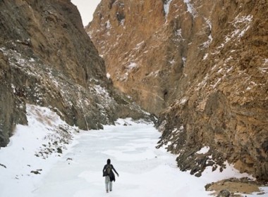
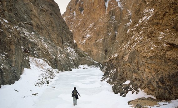
Hugnu Khan Mountain is located in the distance of 280 km southwest of Ulaanbaatar by the paved road. This majestic mountain has been worshipping by locals since immemorial times until today as a sacred mountain. The mountain and its surrounding is special that it represents forest, mountain steppe and desert zone in an area. The mountain is rich in wild animals such as wild mountain sheep, ibex, lynx, deer, wolf, fox, and hare, many pray of birds and much more. The mountain is keeping many historical items such as ancient tombs, burial mounds, rock inscriptions, rock drawings, monasteries and ruins of cities. Two monasteries, named Old and Young monasteries were sacked by soldiers of Galdanboshigt and monks were castrated while tied in rope. So the mountain was named Hugnu Khan meaning “a mountain where people tied in rope”. It is possible to travel around the mountain hiking, driving or riding horses and camels. There you can have an opportunity to see Gobi and Khangai, ride horse and camel through sand dunes and green shored streams, visit or stay with nomad family in short period not far from Ulaanbaatar.
Khar buhiin Balgas or Tsogtiin Balgas There are a couple of unique ruins in Dashinchilen sum(district), in the south of the aimag, which are worth seeking out if you are travelling between Ulaanbaatar and Tsetserleg, via Ogii Nuur. On the western side of the Tuul Gol, about 35km northeast of Dashinchilen, are the impressive ruins of Tsogt Taijiin Tsagaan Balgas a 17th-century fort that was the home of the mother of Prince Tsogt, a 17th-century poet who fought against Chinese rule. There is a stone stele nearby. About 12km west of the sumcapital, the ruined Khar Bukh Balgas (Khar Bakhin Fortress) is worth exploring and is easy to reach as it's just a few kilometres north of the main road. The fortress, inhabited by the Kitan from 917 to 1120, is sometimes known as Kitan Balgas. A small museum nearby is un-locked by a caretaker when visitors arrive.
Ugii lake is located in the centre of Mongolia,and in the territory of Arkhangai province is one of the fresh watered lake of Mongolia and has 27 km squire area. Average depth is 6.64m, in some sections 15.3m, coastal length is 23.5m. Ugii lake abounds in various types of fish and birds, which creates a incredible natural beauty. Ugii Lake also provides a favorable condition for research work and traveling. Ugii Lake attracts travelers, tourists and nature researchers from Mongolia as well as from foreign countries. More than 150 types rare species of birds dwelling in Ugii lake.
Khosho Tsaidam
The Khosho Tsaidam Turkic monuments are made up of four memorial complexes, including those erected in honour of Bilge Khan, a famous politician of the Eastern Turkish Empire (d. 734), and Kul Tegin, commander-in-chief of the Turkic armed forces and younger brother of Bilge Khan (d. 731).
The Khosho Tsaidam memorials are the most important known archaeological remains of the Turkic Empire, which extended across Central Asia in the 6th -8th centuries AD. The unique information presented in the inscriptions on the steles located here has proven extremely valuable to the study of Central Asian history and culture; in addition, the memorial sites have supplied particular insight into the world view, religious beliefs, architecture, arts, literary development and political relations of the early Central Asian peoples.
In terms of their external and internal structure, these first two memorials are essentially identical, consisting of three sections: an entrance area, containing a stele with Tukic runes and Chinese characters, mounted on a granite pedestal fashioned in the form of a turtle; a prayer temple; and a section containing an altar-stone. However the memorials differ in relation to the human and animal statues and the arrangement of the buildings they contain, as well as in terms of their state of preservation. The remaining two memorials contain stones engraved with flower and bird figures, but it is unknown to whom these are dedicated. These smaller memorial complexes also include the remains of surrounding walls and moats, engraved square stone fences, human and animal statues, and bal-bal stones, as well as traces of a former temple.
Although the dates of the Bilge Khan and Kul Tegin memorials are clearly recorded, there is nothing stated in historical sources about the other memorials located nearby. However, as a result of archaeological studies and investigations, it is possible to say that all of them were built during the same approximate time period, considering the similarity of their designs, structure, and customs. Thus, many scholars have concluded that the monuments were established in the 730s in honour of Turkic kings and aristocrats, and were destroyed by Uighurs only about ten years after their establishment. The Uighurs broke down nearly everything including the figures of the king and his attendants.
Recent excavations at the Khushuu Tsaidam site have led to the discovery of many interesting objects, including two headless sheep statues from the entrance to the Bilge Khaan memorial; the broken half-torso of a human statue made of coarse white granite, with missing head and right arm, holding a flat object in the fingers of the left hand, situated between the turtle stone and the offering-temple; a golden crown ornamented with the figure of a mythical bird; gold and silver containers; and a silver deer figure.
Bilge Khan Memorial
Mogilyan, son of the Turkic Khan Ilteris, was born in 683. He became leader of the Turks in 716 and was accorded the title of "Bilge", meaning "Wise". During his reign he made significant contributions to the economic and cultural development of the Turkic Empire. Bilge Khan died on February 25, 734, and a sacrificial temple built in his honour was constructed on June 22 of the following year.
The memorial complex is surrounded by a square wall measuring 96 x 60 metres, inside of which are the traces of a moat. In the western part of the central enclosed area there is a square-shaped sacred stone (2.4 x 1.2m), and in the centre of the complex are located the square foundations of the former sacrificial temple. A white marble turtle monument is located in the eastern part of the area. The central part of the monument has a compressed earthen floor, with a thickness of 40 cm. So-called " balbal " stones extend eastwards in a line from the stele installed on the back of the turtle monument for about 3 km. These stones are believed to correspond either to the number of enemies exterminated by the hero, or alternatively to the number of people who participated in the funeral ceremony.
The most impressive element of the Bilge Khan memorial is its runic stele, which has broken apart into three pieces but remains highly legible. The top of the monument is decorated with the figure of a twisting dragon, while the front is decorated with the figure of an ibex, apparently the totemic symbol of Turkic khans. The principal text of the stele describes the ancestry, honours and achievements of Bilge Khan; on the rear face of the monument there is also a message of condolence sent by the Tan Emperor, inscribed in Chinese characters. The memorial complex further includes several human statues, among which are the carved statues of a man and woman seated in a cross-legged position, assumed to represent Bilge Khan and his queen. The heads of these monuments were all cut off by the Uighurs at the time of their conquest of the Turkic Empire.
Kul-Tegin Memorial
Kul Tegin was born in 684 as the youngest son of Ilteris, the Turkic King. He began taking an active political role from the age of 16. He also played an important role in raising his brother to the rank of king. Kul Tegin devoted all his strength to developing and implementing political, economic and international relations policies of the Turkic empire. He passed away on February 27, 731 and was interred on November 2 of the same year. The memorial temple was completed on August 1, 732 . It is noted in historical sources that the funeral ceremony was an impressive one, attended by numerous representatives from all over the world.
In the centre of the memorial complex, there was a sacrificial temple measuring 10 x 10 metres, built upon a special stage. Its walls were covered with white adobe and were painted red, with coloured murals on the inner walls. The remains of 16 pillars, which formerly supported the roof of the temple, are still preserved. The area surrounding the temple was paved with square bricks measuring 32 x 32 x 6 cm. This brick floor was surrounded by square walls measuring 67 x 29 m, which in turn were surrounded by a moat. In the western wall, there were 2.9 metre-wide gates. Two stone sheep were placed on either side of the gate. There is a turtle monument 8 metres within the gates, which formerly supported a stele with runic and Chinese inscriptions. This stele had fallen down and broken into pieces, but was located and restored in 1911.In the area between the gates and the worship-temple, there were figures of attendants and members of Kul-Tegin's entourage, placed in two lines facing one another. The heads of these statues are missing, presumably having been cut off by the Uighurs during their attack on the Turks. Inside the temple, there were originally placed the cross-legged figures of Kul-Tegin and his wife, of which only very basic remains are extant. During the course of excavations in 1958, the heads of Kul Tegin and his wife were found. A row of approximately one thousand "balbal" stones extends for about 3 kilometres from the gates.
The most significant element of the Kul-Tegin monument is the stele located within the complex, measuring 3.33 x 1.32 x 0.46 m. The top of the monument is decorated with two dragons; further down is a wild goat, totem of the Ashina tribe. Covering three sides of the monument, there are a total of 68 lines of script containing approximately one thousand runic characters. The stele was originally erected on the back of the nearby turtle monument, with its front side - showing the totemic symbol - facing the direction of the rising sun. The stele actually contains several separate inscriptions which were carved at different times. The main text was inscribed over a period of twenty days on Kul-Tegin's orders, by his grandson Yolug. On the rear of the monument were inscribed the words of condolence sent by the Tan Emperor Min-Huan. Two smaller inscriptions were later added to the side of the monument containing Chinese characters.
Khar Balgas
Ordu-Baliq « the city of the army » is located in the grassy plain of Talal-khain-dala steppe, in the Arkhangai province, at around 30km away from the ancient capital Kharkhorin. Also known under the names of Mubalik and Karabalghasun, was the capital of Uyghur Khaganate. For over a century, Ordu-Baliq was the capital of Uyghur Khaganate. Its ruins, Kharbalgas « the black city », are now part of the world heritage site : « Orkhon Valley cultural landscape ».
In 744 Ordu Baliq was established as capital, but collapsed in 840 with the conquest of the turcs Yenisey Kyrgyzes. Therefore with a wingspan of 32km2, the former capital was split into three parts, a central part devoted to the royal residence, as well as the religious area with their numerous temples. This mini-citadel Ordu Baliq not only played a major role as commandery, but also as a commercial warehouse, due to its location on the Silk Road. According to archaeological findings, parts of the city were devoted to crafts and trade exchanges. Today we can still observe on the site the remains of the fortifications and some administrative and merchants buildings. The Russian archaeologist Nikolay Yadrintsev discovered a monument picturing a dragon at the glory of the Khagans, the Mongolian kings.
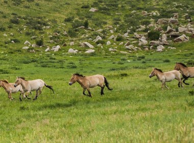
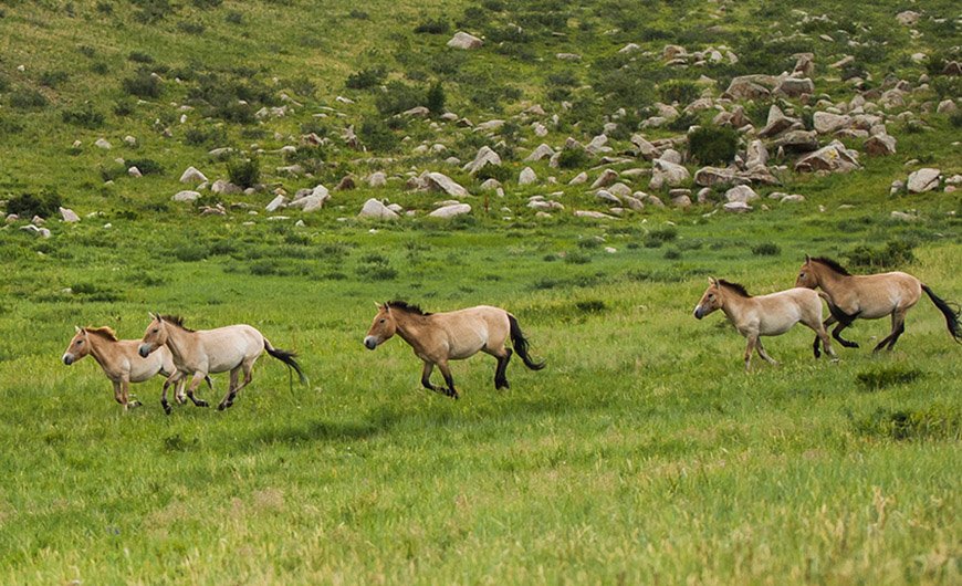
Khustai National Park
The nature reserve is about 100km (62mi) south-west of Ulaanbaatar. The Khustain Nuruu Nature Reserve was established in 1993 to preserve Mongolia's wild Takhi horses and the steppe environment in which they live. The Takhi is probably the most recognized and successful symbol of Mongolia's diverse and unique wildlife. Also known as Przewalski's horse (named after the Pole who first took an interest in them), the Takhi used to roam the countryside in great herds. In the 1960s they almost became extinct because poachers killed them for meat, and because development and livestock overgrazing reduced their fodder. In the early 1990s, with assistance from international environmental groups, many Takhi were reintroduced into specially protected areas in the 90,000ha (222,300acre) Khustain Nuruu and in the south Gobi. About 200 now live in this park or in the wild. In addition to the Takhi, there are populations of maral (Asiatic red deer), steppe gazelle, deer, boar, manul wild cat, wolf and lynx. A visit to the park has become a popular overnight excursion from Ulaanbaator in recent years.
Entry to the park is a one-time fee of US$15. It's worth spending at least one night in the park as you are most likely to see Takhi and other wildlife at dusk or dawn.
The park is run by the Mongolian Association for the Conservation of Nature and the Environment (MACNE), with the cooperation of the Foundation Reserves for the Przewalski Horse (FRPH) and the support of the Dutch government.
The information centre at the entrance to Khustai National Park has a ger with displays on the park and the Takhi horse, as well as a small souvenir shop. Ten kilometres South into the park's core area is the former park headquarters, where there is a Takhi enclosure.
A good horse riding trip takes you to some Turkic graves in the south-east of the park and then on to the Tuul Gol. With your own jeep you can drive to the Moilt camp, stopping at Takhi enclosures en route. Park regulations require you to take a park guide and stick only to existing tracks. Wildlife watching is best at dusk and at dawn. One of the best places to head for is the Tuul Gol, where Takhi usually come to drink in the evening.
TAKHI - THE REINTRODUCTION OF A SPECIES
The Mongolian wild horse is probably the most recognized and successful symbol of the preservation and protection of Mongolia's diverse and unique wildlife. The Takhi, also known as the Przewalski horse (named after the Polish explorer who first 'discovered' the horse in 1878) used to roam the countryside in great herds.
The last wild Mongolian Takhi was spotted in the western Gobi in 1969. At that time, only about a dozen Takhi remained alive, living in zoos in Russia and Europe. Special breeding programs in Australia, Germany, Switzerland and the Netherlands have brought the numbers of Takhi outside of Mongolia to about 1500. The entire global population of Takhi are now descended from the bloodline of three stallions and so computerized records have been introduced to avoid inbreeding.
Between 1992 and 2000, with assistance from international environmental agencies, Takhi were reintroduced into Mongolia at Khustai Nuruu, and Takhiin Tal, in the South Gobi. Today there are currently 107 Takhi in Khustai and 59 in Takhiin Tal.
The Takhi are the last remaining wild horse worldwide, the forerunner of the domestic horse, as depicted in cave paintings in France. They are not simply horses that have become feral, or wild, as found in the USA or Australia, but a genetically different species, boasting two extra chromosomes in their DNA make-up. The Takhi are sandy coloured except for a dark dorsal stripe. The tail and legs are dark and the legs have zebra stripes. The skull and jaw is heavier than a horse's, there is no forelock and the mane is short and erect.
New arrivals are kept in enclosures for a year to help them adapt to a new climate. The laws of nature are allowed to run their course; average five foals are killed by wolves every year in Khustai. The park gets locals onside by hiring herders as rangers, offering cheap loans to others and offering employment at the park's cheese-making factory on the outskirts of the park.
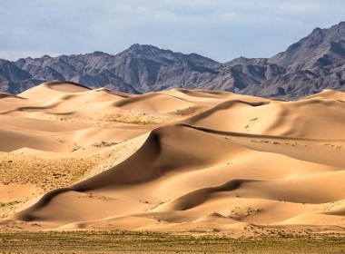
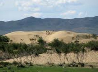
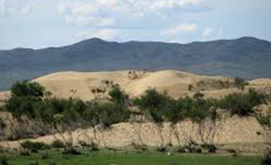
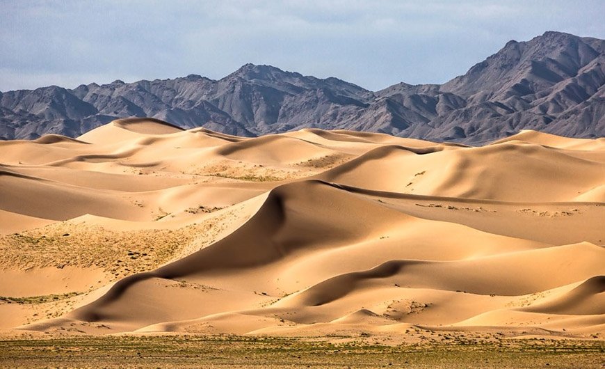
This 80-km sand dune is situated in a terrain of 3 Soums, Erdenesant of Tuv Aimag, Burd of Uvurkhangai, Gurvanbulag of Bulgan Aimag, starting from west of Mount Batkhaan and stretches along west of Mount Khugnu Khan . The main road separates this sand dune into two parts, Mongol Els on the south and Khugnu Tarnyn Els on the north. The sand is sodden under its surface, so shrubberies such as willow, elm and dogwood, grow in the area. There are many tourist camps around the sight. Elsen Tasarkhai is surrounded by Mount Khugnu Khan on the north and Mount Ikh Mongol on the south.
Shankh Monastery
Shankh Monastery located in Ovorkhangai Province, Central Mongolia, 25 kilometers South East of Kharkhorin city, is one of Mongolia’s oldest and most historically significant monasteries. It was founded in 1647 by Zanabazar, the first Jebtsundamba Khutuktu, or spiritual head of Tibetan Buddhism for the Khalkha in Outer Mongolia, around the same time as the establishment of the nearby Tövkhön Monastery.
The monastery belongs to the Gelupa, or Yellow Hat Sect, school of Tibetan Buddhism. Its main temple is famous for its seven Kalachakra Mandalas which portray all 722 Kalachakra deities, the only ones of their kind in Mongolia.
The meaning of the word shankh is unclear, with some speculating it refers to the small mountain range between the monastery and Erdene Zuu Monastery,while others claim it is a term that refers to “a group of objects arranged in a particular order”.
Zanabazar founded Shankh Monastery in 1647 when he was just 12 years old. For many years it was known as the “Monastery of the West” (Baruun Khüree). It began as a ger monastery, and moved several times before settling in its current location in 1787 and taking on its current name.[2] Nevertheless, a large number of monks continued to maintain the traveling camp until the late 19th century.
According to the Russian ethnographer Aleksei M. Pozdneev, who visited the monastery in 1892, in addition to the main temple, built between 1710 and 1790, it consisted of five large beautifully decorated gers that could accommodate nearly 200 people.[3] It is said that the black military banner of Genghis Khan was housed at the monastery for a time, although the current whereabouts of the banner are unknown. [4]
At its height the monastery included several schools that practiced Tantric rituals, especially Kalachakra, Buddhist philosophy and astrology. By 1921, the year of the Mongolian People's Revolution, it consisted of some 20 buildings and housed over 1500 monks.[5]
Like most of Mongolia's religious centers, Shankh Monastery was closed down in 1937 and most of its standing structures destroyed by the country's communist regime as part of violent Stalinist purges. Many of its monks were executed or sent to labor camps in Siberia while 5 young novices were permitted to return to their families.[6] The main temple, which had escaped major damage, was later used as a warehouse. Fortunately, most of the monastery's precious relics were removed and hidden away one of the young novices, Gombo, and thus survived the destruction of the monastery.
After the 1990 Democratic Revolution in Mongolia, the surviving novices returned to Shankh and began restoration efforts on the main temple. In 1993 the Dalai Lama sent three Tibetan monks to Shankh as part of efforts to agton cultivate Buddhism to the country.
Orkhon Valley Cultural Landscape
Orkhon Valley Cultural Landscape (Mongolian: Орхоны хөндийн соёлын дурсгал) sprawls along the banks of the Orkhon River in Central Mongolia, some 320 km west from the capital Ulaanbaatar. It was inscribed by UNESCO in the World Heritage List as representing evolution of nomadic pastoral traditions spanning more than two millennia. (See List of World Heritage Sites in Mongolia)
For many centuries, the Orkhon Valley was viewed as the seat of the imperial power of the steppes. The first evidence comes from a stone stele with runic inscriptions, which was erected in the valley by Bilge Khan, an 8th-century ruler of the Göktürk Empire. Some 25 miles to the north of the stele, in the shadow of the sacred forest-mountain Ötüken, was his Ördü, or nomadic capital. During the Qidan domination of the valley, the stele was reinscribed in three languages, so as to record the deeds of a Qidan potentate.
Mountains were considered sacred in Tengriism as an axis mundi, but Ötüken was especially sacred because the ancestor spirits of the khagans and beys resided here. Moreover, a force called qut was believed to emanate from this mountain, granting the khagan the divine right to rule the Turkic tribes.[1] Whoever controlled this valley was considered heavenly appointed leader of the Turks and could rally the tribes. Thus control of the Orkhon Valley was of the utmost strategic importance for every Turkic state. Historically every Turkic capital (Ördü) was located here for this exact reason. There were many houses by the bank but they are all gone now.
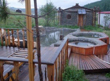
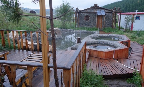
Khujirt Hot Spring
Khujirt is a small town noted for its mineral hot springs. Khujirt hot spa, located 90 km to the south of Karakorum has served as a health resort for several decades. The hot spring, lying at an elevation 1,748 meters above sea level has a number of mineral components, such as bicarbonate, carbonate, sodium and sulfuric hydrogen. The spa water is used for treating nervous, back, extremities and cardiovascular diseases. The temperature of spring water is
+ 55C. For special interest, there are several ancient tombs near the spa.
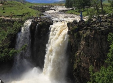
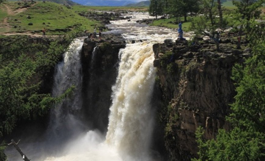
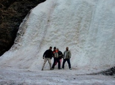
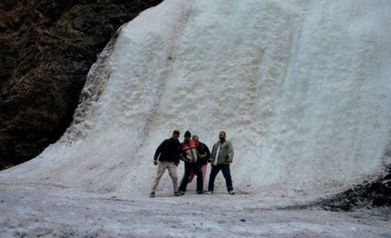
Orkhon Waterfall
Orkhon Waterfall is one of the most visited tourist attractions in Central Mongolia. The waterfall is situated in the historically significant Orkhon valley, whose river flows an incredible 1120km journey to the north before it joins the mighty Selenge river. The height of the waterfall is about 20m. It was formed by a unique combination of volcanic eruptions and earthquakes about 20,000 years ago. The fall is naturally impressive after a heavy rain.
Naiman Nuur - Eight Lakes Area
For nature lovers and adventure travelers the valley of Eight Lakes can be the main destination. The nature in this valley is not disturbed by men and some of horse rider travelers and hiking tour groups are traveling in this valley. There is no possibility to go and to reach there in a car. Only horse riders and walking man can travel in this valley. On the way, you will cross through Siberian pine trees forest and walk along Huis, Haliun, Doroo and in total of 8 lakes, have a rest near by clear water small springs and picturesque small meadows with wild flowers and as well as ancient volcano lava rocks.
Temeen Chuluu Burials Mounds
Orkhon river basin area is rich with ancient graves and burial mounds dated to 5000BC-1000AD. One of the big complex of burail mounds if Temeen chuluu complex, which is located very close to the Uurt river cliff. There are more than 31 mounds with square shapes and with 2 tall monuments with carving of amasing ornaments depicting as deer horns. On the top of this monument the sun and the moon are carved, but there is a thick line on the bottom of this monument. Still present time scholars don't have an all-agreed one conclusion on at what reason the monument was made by ancient nomads.
Tsenkher Hot Spring
Tsenkher Hot Springs: Arkhangai province famous for its many old volcanoes. These volcanoes explain the presence of the springs natural hot water that flows all year long at 1860 meters (1.16 mile) above the sea level. In Tsenkher soum located the Mongolia’s famed Tsenkher Natural Hot springs in 24km. This natural bounty is located 27km south of the town Tsetserleg, and in the center of the Arkhangai province. Set between green forested hills with amazingly beautiful mountains, cliffs and rapid rivers, this geographical gem emerges from the ground at 85.5°C (185.9°F). Tsenkher Hot Springs have healing properties that assist in treating articular diseases and nervous system diseases. The water composition of the hot spring is hydrogen sulfide, sodium carbonate, hydro carbonate, sulfate, and fluorite. The Tsenher Hot Springs provide a place for you to soak in the heat controlled water-pools nestled in a lushly filled mountain valley. This health spa also offers indoor and outdoor baths.
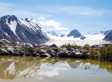
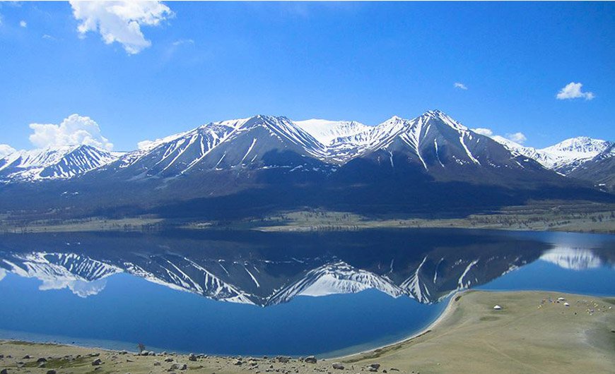
KHORGO VOLCANO - TERKH WHITE LAKE NATIONAL PARK
Khorgo Volcano & Terkhiin Tsagaan Nuur National park was established in 1964 to protect the spectacular mountain scenery and endangered species of fauna and flora. The area has extinct volcanoes, some beautiful lakes, a great number of animals and birds. It is definitely one of the best natural tourist attractions for jeep expidition takers, adventure seekers, nature lovers and outdoor camping tourists.
Amid volcanic craters, pine-clad lava fields and the occasional herd of grazing yaks, the pituresque white lake, as it’s known in English, is the natural highlight of central Mongolia. The lake, birdlife and extinct volcanoes, wild water rivers, and Khangai mountains, which reach as 3000 meters above see level, are now protected within the 77 thousand hectares.
Khorgo Extinct volcano
Khorgo Mountain is a dead volcano which lies on the west of Traiat village of Arkhangai province. the Terkhiin Tsagaan Lake in Arkhangai province. (GPS: N48° 11.187’, E99° 51.259’). The Khorgo crater, situated at an altitude of 2.210 meters with a diameter of 20 meters and depth of 70 to 80 meters, is the most interesting at all. There is no lake in this crater, but clouds of steam jet out it is crevices forming ice moulds in winter, which from a distance look like large flocks of sheep scattered on the mountain. Near the crater there are dozens of small caverns with stalactites hanging from their ceiling and walls.
About 8000 years ago volcanic lava flooded the valleys nearby which are covered today with small forests of Sibirian larch and a great variety of berries and flowers. In the woods there are lots of deer, wild goat and other animals, as well as various kinds of birds such as Red Deer, Siberian Deer, Wild Boar, Ruddy Shelduck and Duck.
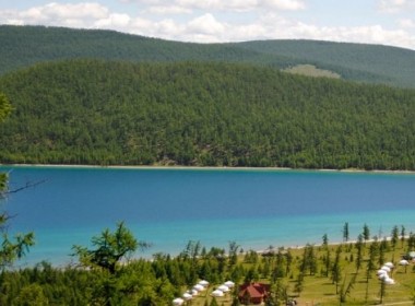
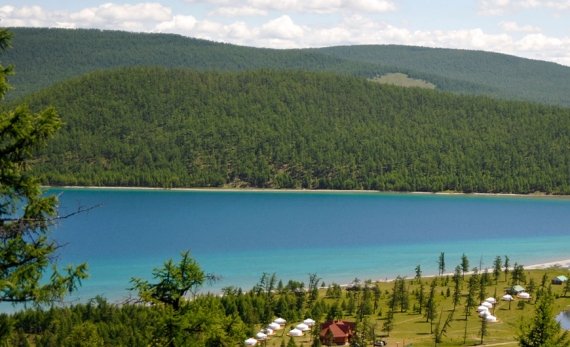
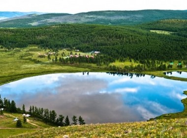
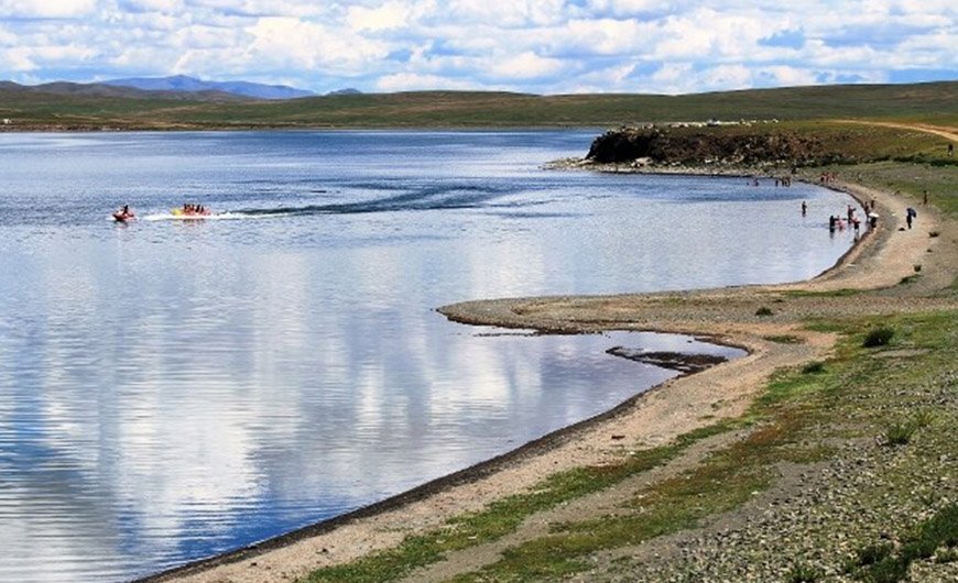
Terkhiin Tsagaan Lake
Terkhiin Tsagaan Lake is an astonishingly beautiful lake with crystal clear fresh water. Torrents of lava issuing from the Khorgo volcano blocked the north and south Terkh rivers, so forming the dammed lake of Terkhiin Tsagaan Nuur at an altitude of 2.060 meters above sea level. The lake is 16 kilometers wide, 4 to 10 meters deep and 20 kilometers in length, a total of 61 sq.meters. The lake supports Pike and other fish. Rare birds are found here. The lake water is frosen in winter time and it melts by mid of May completely.
According to legend, the lake was formed when an elderly couple forgot to cap a well after fetching water. The valley flooded with water until a local hero shot a nearby mountain top with his arrow; the shorn top covered the well and became an island in the lake (Noriin Dund Tolgoi).
The lake is excellent for swimming, though a bit cold in the morning – try the late afternoon, after the sun has warmed it. Hidden along the shore are stretches of sandy beach, perfect for lounging with a book or fishing line. The fishing is great, though you should get a permit for around 10000togrog per day.
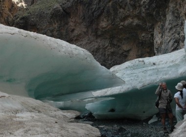
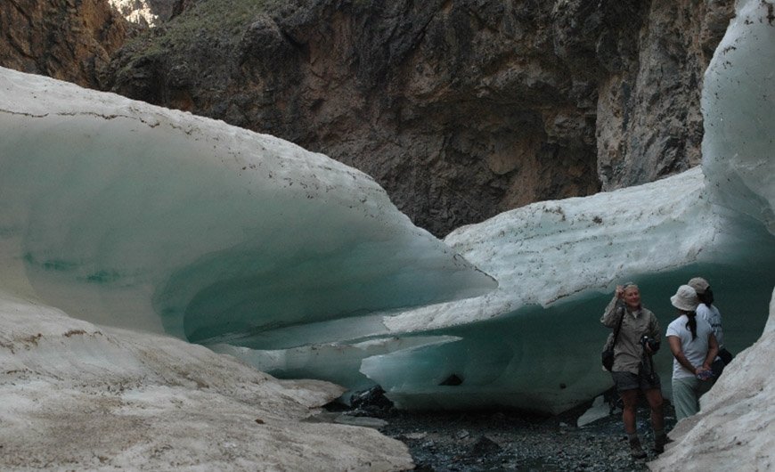
Shar Nohoin aguin Am
Shar Nohoin Am is a cave formed by cooling lava as it flowed away from a volcanic vent. There is a legend, why it is called as Yellow dog cave. A hunter has a yellow dog and they were always traveling together. The man has an accident one day and he fell in this big hole of frosen cave and and injured seriously, could not got out of this big ravine. His yellow dog jumped into the ravine -2o meters deep and helped his owner to get out of it and the dog saved his owner life.
Chuluut River and Choidog Borgio
Chuluut - Stone river gets its sourse from Khangai Mountain range and flowing down in valleys of Khangai and reaches with Delger and Ider rivers and makes one big river Selenge in centralpart of Mongolia.
Chuluut river is the excellent destination for fishermen, specailly for taimen lovers and wolf-taimen seekers. The fish lenth reaches 80 sm up to 150 sm and weight is 15-45lbs. Siberian taimen is aggressive fish, which feeds on anythings even such as minnows, fry, mature grayling, some small birds or rodents.
Choidog Borgio is one of the sportive and wild white water point for rafters and canoers.
POPULAR TOUR

UPCOMING EVENTS