Northern part of Mongolia
NORTHERN PART OF MONGOLIA
Lake Khovsgol Information and Facts
Nicknamed “the Dark Blue Pearl of Mongolia”, Khovsgol Lake is the largest freshwater lake in Mongolia by volume and second largest by surface area. The lake is also the second most voluminous in Asia.
Geographic Facts
Khövsgöl Lake (or Khövsgöl Nuur) is located on the northwestern part of Mongolia, close to the border with Russia. Its northern Mongolian location forms a part of the southern border of the great Siberian taiga forest, in which the infamous Siberian larch tree is dominant.
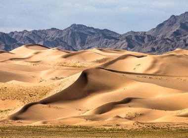
It is surrounded by mountain ranges, craggy peaks and rolling green hills, which are completed with colorful wildflowers during the short summer months. The Khoridol Saridag and the Bayan Mountain Ranges are located at the western part, whilst the Munkh Saridag Mountain Range occupies the northern shore of the lake. On the east one can find sloping mountain sides covered by lush forests between flat-topped mountains, which are the source of 29 of the lake’s tributaries. The highest peak is the Burenkhaan, also known as the Monkh Saridag, with a height of 3,492 meters, located at the northern end of the lake, at the Mongolian-Russian border.
The lake is considered to be the most scenic destination in the country. From a geological point of view, Khovsgol is the younger sibling of the Siberian Lake Baikal, which is located 195 kilometers to the northeast, and was formed by the same tectonic forces 23 million years earlier.
Khovsgol Nuur starts at the town of Khatgal in the south and stretches towards the border with Russia. The town of Hatgal is located at its southern end. Four main islands can be spotted on the lake: Modon Khui, Dalain Khui, Khadan Khui and Baga Khui.
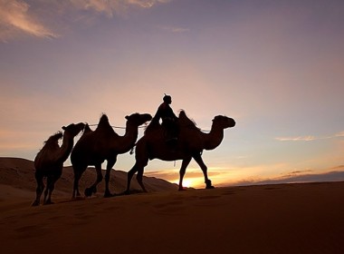
Lake Khövsgöl was first used for transportation in 1913 by Russians and is still in use today. During winter when the water freezes, transport routes were installed on the lake’s icy surface, offering shortcuts and alternatives to local roads. This is now forbidden to prevent pollution from oil leaks and trucks, which broke through the ice. Some 30-40 vehicles sunk in the lake over the past years.
Hydrology
Khövsgöl Nuur holds nearly 70% of Mongolia’s freshwater and 0.4% of all the freshwater in the world. It has a relatively small watershed, and is fed by 46 small tributaries. The lake drains on the south by the Egiin gol River, which makes its way southeast and pours into the Selenga River, thence into Lake Baikal. The water travels 1000 kilometers to reach Lake Baikal from Khovsgol and falls a total of 1,169 meters.
The lake’s surface totally freezes over during the winter and produces an ice which is 1-1.5 meters thick. The ice layer starts to form at the end of fall and can stay frozen until June.
Flora and Fauna
The lake provides habitat for 10 different species of fish and 44 different water plants. Its shores are home to 750 plant species. 291 species of birds can be seen around the lake, of which 258 are migratory birds. The Baikal teal, the bar-headed goose, the black stork and the Altai snowcock are some of the best-known birds.
68 mammal species were discovered here, of which 10% are endemic. The abundance of wildlife is mostly represented by ibex, argali, elk, wolf, wolverine, musk deer, brown bear and the Siberian moose.
The most popular fish living in the lake are Eurasian perch, burbot, salmon, sturgeon, grayling, and lenok. The Hovshol grayling also lives in the lake, and although it has become endangered because of poaching, it is still abundant through much of the lake.
Ecology
Khovsgol Lake is one of the 17 ancient lakes in the world, formed more than 2 million years ago. Because it is so clear, locals use its potable waters without any treatments. It is the most significant source of drinking water in the country. The lake area is a huge national park, and is very strictly protected and regarded as a transition zone between the Central Asian Steppe and the Siberian Taiga.
The Hovsgol Long-Term Ecological Research Site was established in 1997 and an extensive research program began on the lake. This project is now part of an international network of long-term studies. The LTERS provides the opportunity to nurture the scientific and environmental infrastructure in Mongolia by studying climate change, and developing sustainable solutions to some of the local environmental challenges in the Khovsgol Nuur area.
Origin of its Name and People around the Lake
The lake’s name is derived from the Tuvan word meaning “Blue Water Lake”, whilst the term “nuur” means “lake” in Mongolian. Because of various transcriptions, the lake is often also referred to as “Hubsugul” or “Khubsugul”.
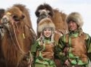
The lake area is home to three separate, unique peoples: the Darkhad, the Buriat and the Tsaatan people. Their religion of choice is shamanism, and they are known to be very spiritual.
Darkhad Valley & Reindeer people
The Darkhad valley is a large valley in northwestern Khovsgol aimag. It is situated between the Ulaan Taiga and Khoridol Saridag ranges at an altitude of about 1600 m, about 160 km long and 40 km wide. The area is 4270 km². It was transferred from the People's Republic of Tuva to the Mongolian People's Republic in 1925 as a Soviet concession to the Mongolians, who had wanted to incorporate the territory of Tannu Uriankhai into their country.
The valley is rich in lakes and rivers, the biggest of which are Dood Tsagaan Lake and Shishged River, respectively. The area is notable for its natural beauty, but relatively remote and inaccessible even by Mongolian standards.
The Darkhad valley is divided between the Ulaan-Uul, Renchinlkhumbe, and Tsagaannuur sums. Inhabitants are mainly Darkhad (whom the valley's name derives from), and also some Tsaatan.
Shamanism, the worship of nature, is the main religion of the reindeer breeders.
Amarbayasgalant Monastery or the "Monastery of Tranquil Felicity", is one of the three largest Buddhist monastic centers in Mongolia. The monastery complex is located in the Iven Valley near the Selenge River, at the foot of Mount Buren-Khaan in Baruunburen sum (district) of Selenge Province in northern Mongolia. The nearest town is Erdenet which is about 60 km to the southwest.
The monastery was established and funded by order of Manchu Yongzheng Emperor (and completed under his successor the Qianlong Emperor) to serve as a final resting place for Zanabazar (1635–1723), the first Jebtsundamba Khutuktu, or spiritual head of Tibetan Buddhism for the Khalkha in Outer Mongolia and a spiritual mentor to both emperors' ancestor, the Kangxi Emperor. Tradition holds that while searching for an appropriate site to build the monastery, the exploratory group came across two young boys, Amur and Bayasqulangtu, playing on the steppe. They were inspired to build the monastery on that very spot and to name it after the two children, Amur-Bayasqulangtu. More likely, the location was chosen because it stood at the place where the lama’s traveling Da Khuree (his mobile monastery and prime residence) was encamped at the moment of the his death. Construction took place between 1727 and 1736 and Zanabazar's remains were transferred there in 1779.
Amarbayasgalant monastery is dedicated to Zanabazar’s main tutelary deity, Maitreya. Unlike Erdene Zuu Monastery, which is an ensemble of temple halls of different styles, Amarbayasgalant shows great stylistic unity. The overriding style is Chinese, with some Mongol and Tibetan influence. The monastery resembles Yongzheng’s own palace Yonghegong in Beijing (converted by his son the Qianlong Emperor into a Buddhist monastery). Originally consisting of over 40 temples, the monastery was laid out in a symmetrical pattern, with the main buildings succeeding one another along a North-South axis, while the secondary buildings are laid out on parallel sides.
Amarbayasgalant was one of the very few monasteries to have partly escaped destruction during the Stalinist purges of 1937, after which only the buildings of the central section remained. Many of the monks were executed by the country's Communist regime and the monastery's artifacts, including thangkas, statues, and manuscripts were looted, although some were hidden until more fortunate times.
Today, only 28 temples remain. Restoration work began in 1988 with funds provided by UNESCO and private sources and some of the new statuary was commissioned in New Delhi, India.
The Uran Togoo - Tulga Uul Natural Monument
The Uran Togoo - Tulga Uul Natural Monument is a national protected area in the Bulgan Province of Mongolia. It is located about 60 km directly west of Bulgan city around the extinct volcanoes Uran Togoo, Tulga, Togoo, and Jalavch Uul.
All four mountain names allude to their volcanic past with designations borrowed from around the fireplace. The Uran Togoo and Togoo mountains are named for their bowl shape, the Tulga mountain for its three mounds reminding of the traditional iron tripod kettle support. Jalavch is a term for a small pot.
Khanuy-Gol is a volcanic field in Mongolia. Khanuy-Gol is located in the northern Hangai range, north of the settlement of Bulgan. It covers a surface area of 3,500 square kilometres (1,400 sq mi). Among the 10 cones with heights of 30–190 metres (98–623 ft) that make up the field are Baga Togo Uul 28metres (92ft) high, Ikh Togo Uul 219metres (719ft) high, Togo, Urun Dush, and Uran Uul. This cone is the highest of the field, with a height of 280metres (920ft). Baga Togo Uul has one maar-like vent among its three vents; these vents are named Javalach, Togo and Tulga. Both Togo cones have a vegetation cover.
Volcanic activity began 12.5 ± 1.0 mya, with trachybasalts erupting along the Hanui River. Later two unnamed cones less than 20kilometres (12mi) west of the river formed Pleistocene lava flows, one of which is 10–12metres (33–39ft) thick. The last eruption is not dated, may be in the Holocene though, judging by Uran Uul's steep sided appearance. The Baga Togo Uul cones are certainly older than 3-4ka and probably Pleistocene. The field is part of the Hangai volcanic region, which is in turn part of the Baikal rift zone. The Hangai region has been subject to tectonic uplift and high heat flow anomalies and hot springs are found.
The rocks erupted by the cones are olivine basalt with inclusions of ilmenite and xenoliths of peridotite in the case of the Togo cones. Some presumably Pleistocene lava flows are basaltic trachyandesites. The Selenga belt of Permian-Triassic age forms the basement of the field. The area is situated in the Khutag-Ondor district of Bulgan Province.
The Khoridol Saridag mountains are a 150 km-long mountain range in Khovsgol aimag, Mongolia, between Khovsgol nuur and the Darkhad valley. The range covers parts of the Renchinlkhumbe, Ulaan-Uul and Alag-Erdene sums. The highest peak is Delgerkhaan Uul (3093m), two other notable peaks are Ikh Uul (2961m) and Uran Dosh Uul (2702m) on the shores of Khövsgöl nuur.
The mountains along the lake are rich in phosphorite, and in the 1980s extensive exploration work was done for open-pit mining. Roads built during that time and other remains, are still visible all over the area. However, due to the political and economic changes of the early 1990s in Mongolia and Russia, those projects were cancelled. In 1997, a protected area covering 1886 km² was founded.
The Khoridol Saridag Mountains to the west of Lake Khovsgol are home to 68 species of mammal including musk deer, brown bear, lynx, marten, beaver, elk, reindeer, moose, argali, ibex and wolf. There are a number of colourful ethnic groups that live in the area including the Dukha reindeer herders who live in teepees and have strong shamanic roots.
This area is one of the best places in Mongolia for horse riding and hiking. From your base in Lake Khovsgol ride or hike with local Darkhat guides through meadows and Siberian forests up into the mountain range, where there is the chance to meet the fascinating ethnic groups that reside in this remote part of the country.
The Shishged River is a river in northern Mongolia and in Tuva. It is part of the Yenisei's drainage basin, and the headwaters of the so-called Little (Small) Yenisei. It flows through the Darkhad Valley in northwestern Khovsgol aimag, Mongolia and then westward through the Ulaan Taiga Mountain range to Russia. There it is joined by the Busein River and Bilin Rivers to form the Kyzyl-Khem. Of its 344 km length, 298 are in Mongolia. A bridge has been erected near Renchinlkhumbe sum center.
Encyclopaedia Britannica, Great Soviet Encyclopedia and Great Russian Encyclopedia do not view Shishged River as a separate river and include it to the upper reaches of the Little Yenisei River.
Olon goliin belchir
“Olon goliin Belchir” which means The Basin of Many rivers, 32 km from Tumurbulag soum of Khuvsgul province. The “Five Rivers” which is the confluence of five rivers: Delgermurun, Bugsei, Ider, and that Chuluut Rivers makes the head of the Selenge Murun / the biggest river of Mongolia/